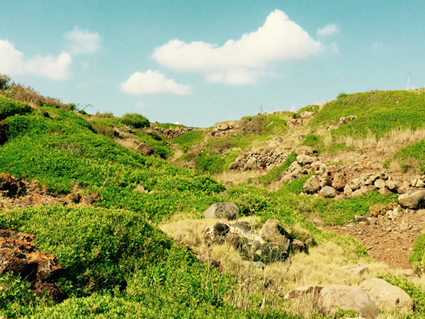
La faglia dell’Arso
La faglia dell’Arso risulta ben visibile per alcune centinaia di metri lungo la strada va da Punta Cavazzi a San Bartolicchio, nel versante sud occidentale dell’isola dove, per effetto dei suoi lenti movimenti, una fascia di terra a ridosso della costa meridionale è stata sospinta verso l’alto a formare la collina dell’Arso. Mettendosi nell’estremità sud occidentale dell’isola, con le spalle al mare, la faglia dell’Arso appare, per alcune centinaia di metri, come un canalone che punta verso la cima del Monte Guardia dei Turchi, facilmente riconoscibile per la bianca cupola che ospita un radar. Anche sul versante opposto, guardando a mare, si distingue la netta frattura del terreno.(FFM)
Estratto da Franco Foresta Martin, Origine ed evoluzione di un’isola vulcanica, Catalogo della mostra sulla storia naturale di Ustica Ustica prima dell’Uomo, Centro Studi e Documentazione Isola di Ustica, 2014
(GE_002)
The Arso fault
The Arso fault is clearly visible for a few hundred meters down the road from Punta Cavazzi to San Bartolicchio, on the western side of the island. There, because of its slow movements, a strip of land near the southern coast has been pushed upwards to form the Arso hill. If we stand in the extreme south west of the island, turning backs to the sea, the Arso fault will appear, for a few hundred meters, as a gully pointing towards the top of Monte Guardia dei Turchi, easily recognizable for the white dome that houses a radar). Even on the other side, looking at the sea, we can distinguish the sharp break of the land.(FFM)
Excerpt from the book: Franco Foresta Martin, Origin and evolution of a volcanic island, Catalogue of the exhibition on the natural history of Ustica, Ustica before mankind, Centro Studi e Documentazione Isola di Ustica, 2014
(GE_002)